Publications

Reconsidering Chronologies and Cultural Change on the South Coast of Peru: A Compilation and Analysis of Radiocarbon Dates from Nasca, Ica, and Paracas

The South Coast of Peru, the location where Peru’s widely used period/horizon relative ceramic chronology was established and where archaeological samples were obtained for the earliest radiocarbon studies, has figured prominently in the development of chronologies in the Central Andes. We examine the current state of chronology in the region with a compilation of 770 published and unpublished radiocarbon dates from ¿60 sites in the Nasca and Ica drainages and on the Paracas Peninsula, spanning a period of approximately 8000 years, to evaluate the relative ceramic chronologies and explore the timing and duration of major cultural changes. Kernel Density Estimate (KDE) summaries of Bayesian phase models demonstrate the following aspects of regional cultural dynamics: the earliest settlements began in the Preceramic ca. 6000 BCE and are found on the coast; the Paracas culture was established ca. 900 BCE and cultural development was first focused in the north and then spread south; a reverse direction of cultural influence is found during the Nasca culture when innovation began in the south and spread north; an early mixture of Late Nasca/local Loro culture is found in Nasca (510–720 CE) followed by the spread of Loro elsewhere and the establishment of intrusive highland Wari colonies that peaked in the mid-9th century CE; and the Late Intermediate Period was variable throughout the region in terms of timing and duration, reflecting a turbulent period. The results of the study reveal strong temporal overlap in the ceramic styles indicating they are not purely sequential and consequently are inadequate as chronological markers on a regional level. The research highlights the potential of radiocarbon evidence to reveal sub-regional temporal heterogeneity and to help us better understand the dynamics of cultural change.

Chronological and Post-Depositional Insights from Single-Grain IRSL Dating of a Palaeolithic Sequence at Stelida, Naxos (Greece)

Since 2015, the Stelida Naxos Archaeological Project (SNAP) has excavated a prehistoric site on what today is the northwest coast of Naxos, the largest island of the Cycladic archipelago in the southern Aegean Sea (Greece). Survey and excavations at the site have produced artefacts spanning the Lower Palaeolithic through the Mesolithic periods based on their techno-typological attributes. These discoveries suggest that exploitation of Stelida began as early as the Middle Pleistocene, challenging the long-standing model that the Cyclades were not inhabited until the Early Holocene. Due to the site’s likely temporal depth and the lack of preserved organics, luminescence dating is the most appropriate method to scientifically date this activity. However, luminescence dating in this context is complicated by the site’s complex hillslope formation processes. Experiments upon the Stelida sediments have demonstrated a lack of luminescence sensitivity of quartz at the site. To evaluate the potential for post-depositional mixing of previously acquired dates yielded from a stratigraphic sequence first published in 2019, as well as to evaluate the efficacy of multiple luminescence dating models, we measured and compared different infrared stimulated luminescence [IRSL] measurements on K-feldspars, with IR50 and pIRIR290 multi-grain and pIRIR290 single-grain signals. The single-grain results confirm the multi-grain results and provide additional and more precise information on the site’s depositional and post-depositional events. The results of each approach demonstrate that feldspars were well-bleached, suggesting that in hillslope settings where quartz grains prove difficult to date, IR50 and pIRIR290 multi-grain, and pIRIR290 single-grain signals of feldspars can be used to achieve reliable results. Finally, when considered alongside field and laboratory observations of site stratigraphy, these results suggest that colluvial and aeolian (windblown) deposits at Stelida retain a degree of stratigraphic integrity characterized by minimal post-depositional alteration following their most recent deposition. These support previous estimates of the deposition at the site, the new earliest deter- mination being 233 – 217 thousand years ago [ka], compared to the date of 198.4 ± 14.5 ka published in 2019. These dates represent the earliest – indirect – evidence for open sea crossings in the northern hemisphere, though it remains uncertain as to which species of the genus Homo was responsible for such maritime activity. These results also have implications for the preservation potential of similar deposits across the hillslope, as well as deposits preserved in similar geomorphic settings in Mediterranean landscapes.

Seeking Synchronicity: Re-examining the Peruvian Early Horizon through Bayesian Modeling of 14C Dates
Google Earth Engine for Archaeologists: An Updated Look at the Progress and Promise of Remotely Sensed Big Data

A wealth of remotely sensed data has accumulated over the past several decades and now constitutes an analytical resource primed for archaeological applications. To date, remotely sensed big data (RSBD) analytics in archaeology have focused on filling spatial gaps in the distribution of sites and features, characterizing environmental landscapes, and monitoring cultural heritage sites. The scientific promise of these data to expand our understanding of past human-environment interactions has not been fully realized. Limitations of data access, sufficient analytical and computational resources, and methodological awareness and education on the appropriate use of RSBD have limited the adoption and widespread use of RSBD in archaeology, despite its ubiquity in the Earth sciences. Google Earth Engine (GEE) is a freely available planetary-scale cloud computing platform that addresses the perennial challenges of data access, analysis, and computing power that are particularly acute among archaeologists aiming to derive insights from RSBD. GEE lowers the barrier to entry for analyzing RSBD, expanding the potential for these data in the automated identification of archaeological features through deep learning; fieldwork planning and archaeological practice; modeling of past environments and environmental variability; and cultural heritage impact and risk assessments. In doing so, it also contributes to open science via increased access, transparency, and reproducibility.

Cappadocian Obsidian Exchange Networks in the Pre-Pottery Neolithic A: A Southern Levantine Perspective from El-Hemmeh (Jordan)

Anatolian obsidian is ubiquitous, but present in only scant amounts, in lithic assemblages recovered from Pre-Pottery Neolithic A (PPNA) settlements of the southern Levant. These sparse quantities have long been interpreted to indicate down-the-line exchange of obsidian via larger regional exchange systems that underpinned information flow amongst early food- producing societies. Here, we explore these networks in the southern Levant through analyses of obsidian artifacts from the PPNA site of el-Hemmeh, Jordan. EDXRF spectroscopy indicates that the obsidian used at el-Hemmeh originated from East Göllü Dağ in central Anatolia, echoing a pattern observed at other southern Levantine sites. We combine obsidian sourcing data for other PPNA sites in southwest Asia with assemblage structure and techno-typological data, to draw out previously unrecognized regional differences in obsidian consumption patterns. This allows us to argue for the existence of distinct exchange networks connecting the inhabitants of the southern Levant and the Middle Euphrates to Anatolian obsidian sources. We conclude that southern Levantine communities accessed their East Göllü Dağ obsidian via a trans-Lebanon and/or maritime route rather than through contemporary communities in the Middle Euphrates.

El Niño Southern Oscillation and Enhanced Arid Land Vegetation Productivity in NW South America

El Niño Southern Oscillation (ENSO) is a periodic disruption of coupled oceanic-atmospheric conditions in the tropical Pacific, which changes global precipitation regimes. One area strongly affected by positive (el Niño) phases is the Pacific Coast of South America. The specific effects of ENSO on Andean ecological communities have received little attention, however. We examine vegetation gross primary productivity (GPP) on Peru’s north coast arid-lands during a recent (2016–2017) el Niño, using a time series of Sentinel 2 imagery. By comparing GPP time-series in three agricultural subregions and three endemic desert vegetation communities, we demonstrate that levels of primary productivity in desert regions during ENSO-positive phases meet or exceed thresholds of adjacent agricultural lands. These results, the first that quantify and spatialize changing GPP between ENSO-neutral and ENSO-positive phases for South American arid-land biomes, both outline the scale and distribution of the el Niño effects on terrestrial ecosystems and highlight the resulting opportunities for human inhabitants. The dramatic changes to endemic vegetation on the normally hyperarid coastal desert of Peru revealed by reconstructed GPP suggest that periodic el Niño precipitation plays a critical role in arid land ecodynamics by enhancing establishment, green growth, and seedbank development. These findings improve our understanding of ENSO’s net effects and highlight the roles of abrupt climate events in the arid land ecology of NW South America.

Traditions Émergentes: Chavín et Cupisnique
The Freston Causewayed Enclosure, Suffolk: Initial Insight and Hypothetical History

dots This paper details the large causewayed enclosure at Freston on the Shotley peninsula in dots Within this framework we primarily contextualise Freston within its East Anglian setting while dots

Expanded Agroecological Niches and Redistributed Risks in Northern Peru's Chicama Valley during Late-Holocene ENSO Climate Changes

South American arid lands present unique constellations of climatic risk to their human inhabitants, due to volatile events that can create markedly different hydroclimate conditions over interannual–centennial scales. However, a main driver of such volatility – the El Niño/Southern Oscillation (ENSO) – occurs with semiregular periodicity. Paleoclimatic and archeological evidence indicate not only that the strength and periodicity of ENSO patterns have changed over the late-Holocene, but their impacts were likely recognized, adapted to, and perhaps capitalized upon by agriculturalists employing adaptive risk strategies. We examine relationships over the last 1.3 kyr between ENSO periodicity, ecological transitions, and archeological settlement in Peru’s Chicama Valley through a coupled paleohydroclimate and agroecology model. We reconstruct periods when ENSO-like conditions dominated past hydroclimates and present a quantitative, spatially-explicit analysis of ecological productivity during modern ENSO-positive hydroclimate conditions. We show that archeological settlement patterns are sensitive to these transformations and reflect efforts to capitalize on expanded agroecological niches. Such expanded niches potentially offset the adverse impacts and risks associated with abrupt ENSO climate events. These results suggest archeological communities were aware of ENSO risk and managed productive strategies accordingly, highlighting the importance of a risk calculus that considers the net ecological effects of climate events.

Developing Transdisciplinary Approaches to Sustainability Challenges: The Need to Model Socio-Environmental Systems in the Longue Durée. Sustainability 2022, 14, 10234
Climate and Demography Drive 7000 Years of Dietary Change in the Central Andes

Explaining the factors that influence past dietary variation is critically important for understanding changes in subsistence, health, and status in past societies; yet systematic studies comparing possible driving factors remain scarce. Here we compile the largest dataset of past diet derived from stable isotope $δ$13C‰ and $δ$15N‰ values in the Americas to quantitatively evaluate the impact of 7000 years of climatic and demographic change on dietary variation in the Central Andes. Specifically, we couple paleoclimatic data from a general circulation model with estimates of relative past population inferred from archaeologically derived radiocarbon dates to assess the influence of climate and population on spatiotemporal dietary variation using an ensemble machine learning model capable of accounting for interactions among predictors. Results reveal that climate and population strongly predict diet (80% of $δ$15N‰ and 66% of $δ$13C‰) and that Central Andean diets correlate much more strongly with local climatic conditions than regional population size, indicating that the past 7000 years of dietary change was influenced more by climatic than socio-demographic processes. Visually, the temporal pattern suggests decreasing dietary variation across elevation zones during the Late Horizon, raising the possibility that sociopolitical factors overrode the influence of local climatic conditions on diet during that time. The overall findings and approach establish a general framework for understanding the influence of local climate and demography on dietary change across human history.

The Influence of Ancient Herders on Soil Development at Luxmanda, Mbulu Plateau, Tanzania

In eastern Africa, ecologists have found that when mobile pastoralists abandon their temporary encampments, the accumulation of burned animal dung, wood, and other organic waste enriches the concentration of nutrients (e.g., calcium, phosphorous, magnesium) essential to soil health, in comparison to other soils without prior human habitation. These nutrient-enriched soils promote glade development and greater biodiversity. Geoarchaeological research on the time depth of this anthropogenic ``nutrient hotspot’’ phenomenon has demonstrated that soils at several archaeological sites in southern Kenya still remain enriched in these soil macro- and micro- nutrients after several thousand years. However, soil scientists and geoarchaeologists do not yet understand how these anthropogenic soils vary over the extensive geographic conditions of eastern Africa. The discovery of a Pastoral Neolithic site (ca. 3000 BP) at Luxmanda on the Mbulu Plateau, Tanzania, provides an opportunity to examine if similar patterns of nutrient enrichment can be detected in a different geological and climatic zone.In this paper, we use geochemical and sedimentary analyses to determine how archaeological soils at Luxmanda differ from adjacent off-site soils and known archaeological soils in Kenya, as well as from computationally derived soil nutrient models for eastern Africa. Our results indicate that soils derived from anthropogenic sediments and ashy dung are 4 to 16-fold more abundant in soil macro nutrients relative to off-site or modeled values. This pattern fits previous studies’ observations thatelevated macro- and micro-nutrients in soils are strongly correlated with ancient pastoralist habitation sites. We conclude that anthropogenic soils found at Pastoral Neolithic archaeological sites may be a valuable, but unappreciated, soil resource in eastern Africa.

Estudios Paleodemográficos Basados En Conjuntos de Dataciones Radiométricas. Una Revisión Crítica
From Paleoclimate Variables to Prehistoric Agriculture: Using a Process-Based Agroecosystem Model to Simulate the Impacts of Holocene Climate Change on Potential Agricultural Productivity in Provence, France

This paper explores the relationship between past climate and prehistoric Mediterranean agriculture by adapting a process-based dynamic vegetation model to estimate potential agricultural productivity under climate scenarios that characterize the extremes of Mediterranean climate in the Holocene. We adapt LPJmL (the Lund-Potsdam-Jena-managed-land model [Bondeau et al., 2007]), a process-based dynamic vegetation model, to the modeling of potential agricultural productivity in the past. Calibrating this model for past crops and agricultural practices and using a downscaling approach to produce high spatiotemporal resolution paleoclimate data, we produce quantitative estimates of potential yields under past climatic conditions derived from four Holocene climatic extremes (warm/wet, warm/dry, cold/wet, and cold/dry) under two different assumptions (approximate high and low limits) about the intensity of agricultural practice. We here discuss this process with reference to a case study in Provence, examining the methodology and data requirements for modeling past agriculture using LPJmL and considering the implications of the range of variability in potential agricultural productivity under distinct climate conditions. We focus particularly on comparing the range of variability induced by climatic shifts with that achievable through changes in agricultural practices as a means of approaching questions of past vulnerability and resilience.

Regional Paleoclimates and Local Consequences: Integrating GIS Analysis of Diachronic Settlement Patterns and Process-Based Agro-ecosystem Modeling of Potential Agricultural Productivity in Provence (France)

Holocene climate variability in the Mediterranean Basin is often cited as a potential driver of societal change, but the mechanisms of this putative influence are generally little explored. In this paper we integrate two tools – agro-ecosystem modeling of potential agricultural yields and spatial analysis of archaeological settlement pattern data – in order to examine the human consequences of past climatic changes. Focusing on a case study in Provence (France), we adapt an agro-ecosystem model to the modeling of potential agricultural productivity during the Holocene. Calibrating this model for past crops and agricultural practices and using a downscaling approach to produce high spatiotemporal resolution paleoclimate data from a Mediterranean Holocene climate reconstruction, we estimate realistic potential agricultural yields under past climatic conditions. These serve as the basis for spatial analysis of archaeological settlement patterns, in which we examine the changing relationship over time between agricultural productivity and settlement location. Using potential agricultural productivity (PAgP) as a measure of the human consequences of climate changes, we focus on the relative magnitudes of 1) climate-driven shifts in PAgP and 2) the potential increases in productivity realizable through agricultural intensification. Together these offer a means of assessing the scale and mechanisms of the vulnerability and resilience of Holocene inhabitants of Provence to climate change. Our results suggest that settlement patterns were closely tied to PAgP throughout most of the Holocene, with the notable exception of the period from the Middle Bronze Age through the Early Iron Age. This pattern does not appear to be linked to any climatically-driven changes in PAgP, and conversely the most salient changes in PAgP during the Holocene cannot be clearly linked to any changes in settlement pattern. We argue that this constitutes evidence that vulnerability and resilience to climate change are strongly dependent on societal variables.

Pastoral Neolithic Settlement at Luxmanda, Tanzania
Hacia Una Geoarqueología Del Paisaje Andina: Paisaje, Medioambiente, y Acción Humana En Chavín de Huántar
The Stélida Naxos Archaeological Project: New Studies of an Early Prehistoric Chert Quarry in the Cyclades
Regional Climate, Local Paleoenvironment, and Early Cultivation at Pre-Pottery Neolithic A El-Hemmeh, Jordan
Open Science in Archaeology
Not Just a Pyramid Scheme? Diversity in Ritual Architecture at Chavín de Huántar
Characterization of the Siliceous Rocks at Stélida, an Early Prehistoric Lithic Quarry (Northwest Naxos, Greece), by Petrography and Geochemistry: A First Step towards Chert Sourcing
Spherulites and Aspiring Elites: The Identification, Distribution, and Consumption of Giali Obsidian (Dodecanese, Greece).
La Incorporación de La Tradición Mito En El Ámbito Ritual de Chavín de Huántar
Early Holocene Interaction in the Aegean Islands: Mesolithic Chert Exploitation at Stélida (Naxos, Greece) in Context
Collaborative Action and Landscape Setting at Chavín de Huántar

The Central Andean ceremonial centre of Chavín de Huántar is situated in a dramatic, mountainous and dynamic environment high on the eastern slope of the Peruvian Andes, yet the site’s landscape setting has remained in the shadow of its monumental architecture, complex lithic art and highly elaborated material culture. Nevertheless, that dynamic landscape setting was an integral part of the site’s significance as a ceremonial centre and may be read as evidence of the capacity, worldview and message of the site’s builders. First, Chavín’s setting is evidence of capacity, demonstrating the considerable degree of labour mobilization and organization, as well as expertise, implied by the site’s modified landscape. Second, Chavín’s landscape, considered in its Central Andean context, provides evidence of worldview, demonstrating that landscape setting was a medium of interest for Chavín’s designers. Third, the modified landscape provides evidence of message, allowing exploration of what Chavín’s designers were trying to communicate, and to whom. Focusing on these three aspects in reading Chavín’s landscape suggests that landscape setting was a vital aspect of Central Andean Middle and Late Formative Period (1000–500 bce) ceremonial centres and argues that emergent elites actively exploited landscape setting as a communicative medium and forum for dissemination of ideology, deliberately communicating to multiple audiences.

The Stélida Naxos Archaeological Project: New Data on the Middle Palaeolithic and Mesolithic Cyclades
Summed Radiocarbon Calibrations as a Population Proxy: A Critical Evaluation Using a Realistic Simulation Approach

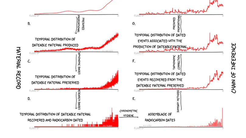
The logic of using summed radiocarbon (14C) calibrations (cumulative probability density functions for large numbers of calibrated 14C dates) as proxies for past populations rests on the presumption of a proportional relationship between population size and the production, and subsequent preservation, recovery, and analysis, of 14C-datable material. Critiques of this approach have generally focused on the various problems that may undermine the validity of this assumption. \n Here, instead, we presume a perfect correspondence between population size and the quantity of datable material produced at any given time, and explore the question of how well summed 14C calibrations can track demographic changes under such ideal circumstances. We introduce a method of generating a random sample of simulated 14C determinations, from a specified distribution, with variable data densities and measurement errors. In other words, we generate a random sample of 14C dates not from an ideal statistical distribution but rather using a defined population curve to determine the probability distribution from which the calendar dates of the simulated 14C samples are drawn. We generate simulated 14C ages for these samples, calibrate them, and sum those calibrations. We compare the resulting proxy population curve to the known population distribution from which it was generated, to see whether known population fluctuations are unambiguously visible on a proxy curve derived from 14C data sets that are realistic in terms of the number and precision of the 14C determinations included. \n Results highlight 1) the critical role played by the magnitude and duration of any population fluctu- ation, and 2) the importance of sample size, and the reality that the numbers of samples required to detect significant population changes are generally far higher than those available to researchers pro- posing demographic reconstructions on the basis of literature searches for radiocarbon dates. We conclude that even if archaeological 14C data sets could be corrected for taphonomic filters and research biases, demographic signals would be difficult to distinguish from statistical noise in summed probability distributions. We suggest that simulation studies should be integral components of any attempt to reconstruct prehistoric demography from 14C dates.

(Re) Constructing the Sacred: Landscape Geoarchaeology at Chavín de Huántar, Peru
(Before and) After the Flood: A Multiproxy Approach to Past Floodplain Usage in the Middle Wadi El-Hasa, Jordan
Archaeological Approaches to Obsidian Quarries: Investigations at the Quispisisa Source
The Economics of the Looted Archaeological Site of Bâb Edh-Dhrâ': A View from Google Earth
The Character and Use of the Soros Hill Obsidian Source, Antiparos (Greece)
Investigaciones En La Fuente de La Obsidiana Tipo Quispisisa, Huancasancos- Ayacucho
Shining Light on Looting: Using Google Earth to Quantify Damage and Raise Public Awareness
La Cronología de Chavń de Huántar y Sus Implicancias Para El Periodo Formativo

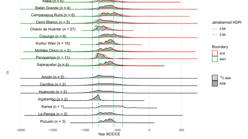
Chavín de Huántar es uno de los sitios fundamentales para entender el Periodo Formativo en los Andes centrales. Irónicamente, a pesar de muchas décadas de investigaciones realizadas por docenas de investigadores, su cronología es todavía debatida e insegura. Este artículo presenta una reseña de la evidencia histórica para la cronología de Chavín, enfatizando la contribución de los fecha- dos radiocarbónicos calibrados y, de manera breve, revisando los que están temporalmente relacionados con otros sitios formativos. Se analizan, también, los numerosos fechados de carbono-14 asociados a cerámica y contextos arquitectónicos conocidos en Chavín derivados de estudios recientes. De hecho, muchos fechados de Chavín y sitios relacionados concuerdan en ubicar a la cerámica negra pulida estampada, denominada janabarroide, alrededor de 800-500 a.C. (calib.). La presencia de ocupaciones anteriores y posteriores, documentadas con fechados, ayudan a confirmar este rango temporal para materiales reconocidos del «Horizonte Temprano». En contraste con algunos otros importantes sitios formativos, Chavín deja de funcionar como templo hacia 500 a.C. (calib.), aunque los esfuerzos destinados a las construcciones principales ya estaban disminuyendo, de manera notable, antes de esta época. \n Chavín de Huántar is one of the key sites of the Formative Period in the Central Andes, with many decades of investigations by dozens of investigators, but ironically its chronology is still poorly defined and contested. This article reviews the historical evidence for Chavín chronology, emphasizing an examination of calibrated radiocarbon dates, and summarily reviewing related radio- carbon evidence from approximately contemporary sites. The more voluminous C14 evidence from recent work at Chavín is then examined, particularly focused on dates from known ceramic and architectural contexts. A large number of determinations con- cur, both in and outside of Chavín, in dating stamped polished blackware «janabarroide» ceramics in the range of 800-500 BC in calibrated age. Earlier and later occupations at Chavín are documented, helping confirm this time range for «Early Horizon» materials. Chavín, unlike some other important Formative sites, loses its temple function by around 500 BC calibrated, although major construction seems to have greatly decreased well before that time.

Geomorfología y Paisaje En Chavń de Huántar